Shoreline Protection on Georgian Bay
Georgian Bay has a very long shore with very different kinds of shoreline, a water level that moves by almost two metres between low and high years, and uneven conservation authority coverage. This page covers the level swing, the difference between the rocky eastern shore and the southern shore, and which approvals carry the load where no conservation authority serves. We supply and install shoreline stone across our service area.
The swing between low and high water
Environment and Climate Change Canada keeps a lake-wide record for Lake Michigan-Huron, the water body that Georgian Bay belongs to. Its highest monthly average level on record is October 1986, at 177.50 metres. Its lowest is January 2013, at 175.57 metres. The difference is about 1.9 metres. The year 2020 set the highest annual average, 177.31 metres, with a July peak of 177.46 metres that stayed below the 1986 record.
A shoreline built or repaired in a low year has to work in a high one, and the reverse. The permit authority and a site visit set the water levels a design is checked against. The Ministry of Natural Resources defines shore lands as the lands below the high-water mark of a lake, or the maximum regulated contour if that is higher, so confirm on site where that line sits and do not assume it from a single year.
Two different shores
Ontario's geological guide to the area notes that of all the Great Lakes shorelines, only those of eastern and northern Georgian Bay are carved from gneiss bedrock. That is the Canadian Shield shore, where rock meets the water.
The southern shore, around Nottawasaga Bay and Wasaga Beach, is different. The Nottawasaga Valley Conservation Authority describes it as a dynamic sand beach system, where flood hazard zones shift with sand movement and lake level. A site on a sand shore and a site on bedrock raise different questions, and a site visit settles the design.
Who approves work on Georgian Bay
Conservation authority coverage is uneven. The Nottawasaga Valley Conservation Authority serves 18 municipalities, including Collingwood, Wasaga Beach and The Blue Mountains. Grey Sauble Conservation Authority covers about 219.6 kilometres of Georgian Bay and Lake Huron shoreline in Grey and Bruce Counties. Grey Sauble Conservation Authority administers Ontario Regulation 41/24, in force since April 1, 2024. Ontario's 2019 flood review states that there are no conservation authorities in the Muskoka and Magnetawan watersheds, and Ontario's floods page tells communities not served by an authority to contact their ministry work centre.
Under the Conservation Authorities Act, the Nottawasaga Valley and Grey Sauble authorities amalgamate, with Lake Simcoe Region, Ausable Bayfield, Maitland Valley and Saugeen Valley, into the Lake Huron Regional Conservation Authority on the transition date, February 1, 2027, or a later date set by regulation. Check which authority covers your lot at the time you apply.
Where no authority serves the shoreline, the other bodies carry the load:
- Ministry of Natural Resources. A new erosion control structure on shore lands, or an expansion of one, needs a work permit. Work in contact with more than 15 square metres of Crown shore lands may also need one.
- Fisheries and Oceans Canada. The Fisheries Act covers work that harms fish habitat, and an authorization is needed where a project is likely to cause that harm.
- Transport Canada. On navigable water, erosion-protection works are a class that is posted on a public registry with a public notice. Docks and boathouses that meet the Minor Works Order criteria can proceed without an application.
- The municipality. Severn Township, for example, requires a fill permit above 10 truckloads under by-law 2024-67. Fill is not allowed within 30 metres of any watercourse under that by-law. Wasaga Beach has a beach by-law that protects dunes and wildlife, with fines of $900 to $3,000. Other townships have their own by-laws.
Ontario's erosion page states that municipalities must direct development away from hazardous areas and lists lakefronts among the vulnerable areas, which is why a municipality may ask about hazards even where no authority is involved.
Parks Canada's Trent-Severn Waterway ends at Port Severn on Georgian Bay. Owners near Port Severn should ask Parks Canada whether its permit applies. The full picture is in Shoreline permits in Ontario: who approves what.
How a revetment is built
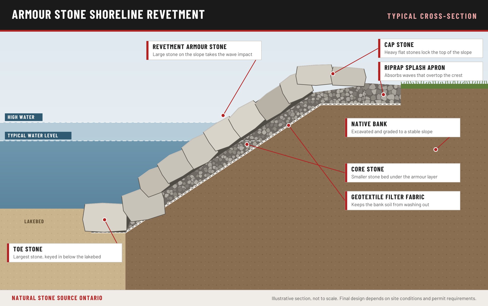
The layers go in from the bottom up: toe stone below the lakebed, core stone, filter fabric, armour stone and cap stone. Slope, stone size and the elevation of the toe and the crest are set at the site visit and in any engineering the permit authority requires.
What shoreline work costs
Shoreline work typically runs from about $500 to $20,000 per linear foot, depending on the scope of work, the height of the bank, the size of the lake and the wave exposure the site takes. Permit fees are extra. Every project is quoted after a site visit.
Questions about Georgian Bay shorelines
Is there a conservation authority on every part of Georgian Bay?
No. Some stretches of the shore are served by authorities such as Nottawasaga Valley and Grey Sauble, and Ontario's flood review states there are no conservation authorities in the Muskoka and Magnetawan watersheds. Your municipality can tell you whether one serves your lot.
Who approves shoreline work where there is no conservation authority?
The Ministry of Natural Resources for a new erosion control structure on shore lands, Fisheries and Oceans Canada for fish habitat, Transport Canada where the water is navigable, and the municipality for site alteration and zoning.
How much does the water level change?
Environment and Climate Change Canada's record for Lake Michigan-Huron shows a highest monthly average of 177.50 metres in October 1986 and a lowest of 175.57 metres in January 2013, a difference of about 1.9 metres.
Planning shoreline work? Call 1-855-787-8663 or Request a Quote.
What to send us: photos of the shoreline, the approximate length in feet, the lake and the township.